Bari Airport – San Pietro in Bevagna transfer – Trasferimento – Tip from Villa Edina

Bari (Karol Wojtyla) International Airport is about two hours by car from Villa Edina (San Pietro in Bevagna). You can rent a car at the airport . You can take a bus or a train as well to get there. For more information see the below link.

https://www.rome2rio.com/it/s/Aeroporto-Bari-BRI/San-Pietro-in-Bevagna

L’aeroporto internazionale di Bari (Karol Wojtyla) si trova a circa due ore di macchina da Villa Edina. È possibile di noleggiare macchina all’aeroporto. È anche possibile prendere un autobus o un treno per arrivarci.

Per ulteriori informazioni consultare il seguente.

https://www.rome2rio.com/it/s/Aeroporto-Bari-BRI/San-Pietro-in-Bevagna

barispbtransfercropfial

The Trulli

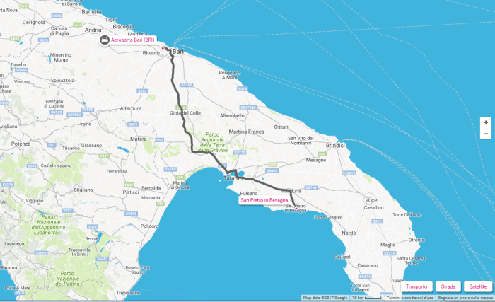
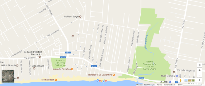
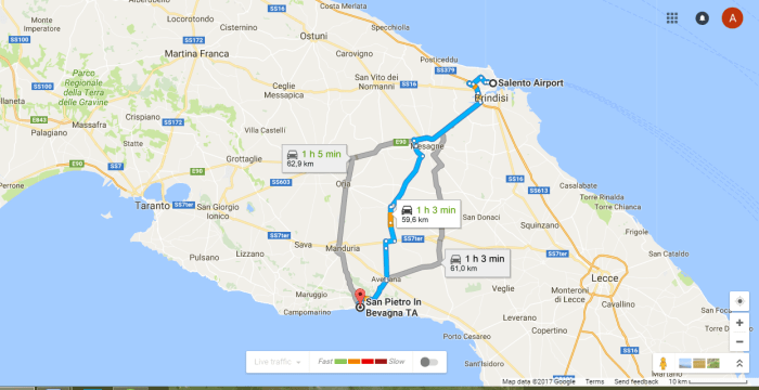
Puglia’s most striking and unique tourist attraction are the trulli. There is a “trulli district” around Alberobello (a UNESCO World Heritage site). But you can find many trulli scattered around in the Salento countryside including the San Pietro in Bevagna area, in the immediate neighbourhood of Villa Edina.

A trullo is a simple dry-stone-walled building with a domed roof topped by a cone. They are dotted around the green Valle d’Itria, and in Alberobello the town’s large clusters of white-washed trulli create an unusual and memorable scene. Alberobello (Italian:  “beautiful tree”) is a small town in Salento with about ten thousand inhabitants.

AlberoBeciroutepicrop.png

Alberobello was first mentioned in the early 16th century when the first 40 families were granted land to farm in the area. The abundance of calcareous sedimentary material in the area lead to the building of houses with dry stone without the use of mortar. These houses were the first trulli which contributed to the expansion of the settlement. Building the houses of dry stone was a requirement of Count Giangirolamo II as in this way it was avoidable to pay taxes on them.

So, a trullo (plural, trulli) is a traditional Apulian dry stone hut with a conical roof. Trulli were generally constructed as temporary field shelters and storehouses or as permanent dwellings by small proprietors or agricultural workers. The golden age of trulli was the 19th century, especially its final decades marked by the quick development of wine growing.

The Italian term il trullo (from the Greek word τρούλος, cupola) refers to a house whose internal space is covered by a dry stone corbelled or keystone vault. Trullo is an italianized form of the dialectal term truddu used in a specific area of the Salentine peninsula (i.e. Lizzaio, Maruggio and Avetrana, in other words outside the Murgia dei Trulli proper) where it is the name of the local agricultural dry stone hut. A stonemason specializing in the building of trulli is a trullisto or trullaro in Italian.

In the countryside, trullo domes were built singly or in groups of up to five, or sometimes in large farmyard clusters of a dozen or two dozen, but never for the occupancy of more than a single rural family. Depending on the area, the building material used could be either hard limestone or calcareous tufa.

In Alberobello, the structural walls of a trullo are laid directly on the bedrock, after removal of the topsoil when necessary. Their width varies from 0.80 metres to 2.70. Their height (from ground level to where the vault starts) ranges from 1.60 metres to 2 metres. The stones needed for starting to build a trullo were provided by digging a cistern (cisterna), an absolute necessity in an area devoid of water. The cistern was capped with a lime-mortared barrel vault or dome which in many cases supported the floor of the house.

The trullo may take on a circular or a square plan. The circular trullo is mostly a temporary shelter for animals and their fodder, or for the peasant himself. The roofs are constructed in two skins: an inner skin of limestone, capped by a closing stone, and an outer skin of limestone slabs that are slightly tilted outwardly, ensuring that the structure is watertight. The roof stones can be taken away without compromising the stability of the rest.

A multi-room trullo house has many cones representing a room each. Along with its exterior wall, a trullo’s interior room and vault intrados were often rendered with lime plaster and whitewashed for protection against drafts.

The trulli used as dwellings all have an open fireplace complete with a flue (hidden in the masonry) and a stone-built chimney stack (rising high above the roof). Because of their design, trulli are difficult to heat: the walls are too thick and warm air will rise up the interior cone. The thick stone walls and dome of the trullo, pleasantly cool in the summer, tend to become unpleasantly cold during the winter months, condensing the moisture given off by cooking and breathing and making it difficult to feel warm even in front of the fire. The inhabitants simply leave the doors open during the day to keep the interior dry, and live more outdoors than inside.

Owing to the concentration of houses, trulli have few openings outside their doorway and a small aperture provided in the roof cone for ventilation. As a result, it can be quite dark inside. Some trullo houses have had their perimeter walls substantially raised so that their cones can be hidden from view, making the buildings look like ordinary houses.

There are many theories behind the origin of the design. One of the more popular theories is that due to high taxaion on property the people of Apulia built dry stone wall constructions so that they could be dismantled quickly when tax inspectors were in the area.

A Plan of the Territory of Mottala drawn by Donato Gallerano in 1704 reveals the existence of a nucleus of trulli in the midst of a large forest, making up the initial settlement of Arbore bello. The urban trulli in Alberobello date from the 18th, 19th and 20th centuries. The trulli settlements started being deserted in the second half of the 20th century. The rural trulli, on cheaper land, ceased to be built when the cost of labour began to rise in the twentieth century. The sheer expense of handling the hundreds of tons of stones necessary for a single house became prohibitive.

Recently a large number of trullo houses have been restored and converted into second homes or self-catering cottages. In 1999, rebuilding a trullo roof would cost about 1,500 euros; in 2009 the cost rose up to 15,000 euros. In late twentieth century, a local craftsman, Guido Antionetta, came up with the idea of buying up a few dozen abandoned trulli, he installed in them modern kitchenettes, a few pieces of wooden furniture and cast-iron bedframes to rent them out as mini apartments. In the Alberobello region, local residents who still live in trulli only do so because they cannot afford to move out or because they provide bed and board for tourists in their trulli.

Let’s go to Lecce!

Lecce. This stunning baroque city is about an hour drive from Villa Edina. Lecce is the Baroque masterpiece of southern Italy, often described as the ‘Florence of the Baroque’ or the ‘Rome of the South’. You have to see this gem.


lecceroutecropbevi

The town has two main focal points: Piazza Sant’Oronzo and Piazza del Duomo. Piazza Sant’Oronzo is the big civic heart of the town, a large square with a slightly strange and incomplete atmosphere, the ancient and the modern sitting uncomfortably together. Among the varied structures here is the town’s excavated Roman amphitheatre. The statue of a bishop perched on a column represents Sant’Oronzo, a patron saint of Lecce. The column is one of two which originally marked the end of the Roman Appian Way in Brindisi (the other is still in Brindisi). Piazza del Duomo is an unusual interpretation of that familiar Italian cathedral square. In Lecce the cathedral sits in one corner of a theatrical enclosed square; a still space in the heart of town. Alongside is the high campanile.

A good way to enjoy an initial introduction to Lecce’s centro storico is to take the little tourist ‘train’ (trenino) which offers a guided tour of the centre.

Architectonic development and rich facade decoration were particularly fecund during the reign of the Kingdom of Naples, and they characterized this Apulian capital in such a unique way as to give birth to the term “Leccese Baroque.”  It is a completely original style, also due to its use of Lecce stone, a type of chalky material – usually in warm colors – that is malleable and pliant.

The streets of the center of Lecce make up part of a museum under the open sky, and one of this museum’s most remarkable exhibits is its splendid Piazza del Duomo, site of the city’s Duomo, Cathedral of Maria Santissima Assunta. The Cathedral features a lovely bell tower and two façades, one rather sober in tone and the other highly-embellished. Other grand symbols of Lecce include Palazzo Vescovile, a Renaissance construction with a beautiful and evocative series of loggias; and Palazzo del Seminario, oft-noted for its ashlar (or hewed, squared stone) decorations and its characteristic cloister.

Not far away is Piazza Sant’Oronzo, a treasure chest in itself of artistic and historic gems, all from different eras. Palazzo del Seggio (also known as the Sedile) dominates the piazza with its Renaissance elegance; today it hosts a number of enlightening and interesting exhibits and expositions. The Church of Santa Maria delle Grazie is in the same architectural style, while the majestic Amphitheatre in elliptical form, naturally, is evidence of Rome’s rule here – as is the Roman column, standing next to the bronze of the city’s Patron Saint, St. Orontius.


In Lecce’s surrounding neighborhoods we find the Church of San Giuseppe, with its Baroque façade, and the Castle of Charles V (Castello Carlo V), a fortified bastion built in the 1500s on the request of Emperor Charles V. The Castle comprises a central structure that was erected much before, in the 12th Century, while other of its elements were completed in the following era (for instance, the ditch). Once used as a defense, the Castle today welcomes visitors to its numerous art exhibits and cultural initiatives.

Another landmark that makes grand impact on the eye is the Porta Rudiae, surmounted by yet another statue of the Patron Saint, this time accompanied by San Domenico and St. Irene. Then, the beautiful façade of the Church of the Rosary seems to reach – in sweeping vertical movements – to the sky. A must-visit is the Basilica di Santa Croce (begun 14th Century), whose high points are its harmonious balance between the Classical and Baroque styles, and the magnificent beauty of its interior. The Basilica was begun in the 14th Century, and completed sometime in the 16th or 17th Century. Then, the monument to Fascism, a work that was headed by Francesco Antonio Zimbalo and Cesare Penna, abounds with Christian symbols and is topped with a large rosette.

Of course, a tour of Lecce would be incomplete without seeing its art galleries and museums. Among them all, the Provincial Archaeological Museum of San Castromediano is one of the brightest highlights for its extremely old artifacts from the Roman and Messapian Civilizations. Not to be left out are the Lecce Historic Museum (also a contemporary art gallery); the Franciscan Art Gallery inside Palazzo Fulgenzio; and the Museum of the Roman Theatre that, besides containing finds from local archaeological excavations, holds a collection of nine theatrical masks from Hadrian’s Villa in Tivoli.

As in many cities of southern Italy, Lecce is teeming with countless evening engagements for those who want to enjoy the arts and be entertained: from music to theatre, the city of Leccese Baroque is animated by lively social life and a vivacious student population, here to attend the local University.

Sources:

http://www.italia.it/en/travel-ideas/art-cities/lecce.html

http://www.italyheaven.co.uk/puglia/lecce.html

Smart shopping when in San Pietro in Bevagna / Shopping intelligente in San Pietro in Bevagna

For large-scale shopping of food and basic household products the best and cheapest way is to drive to the Eurospin mall in Manduria (about 10 kilometers from Villa Edina). See map for Eurospin shops in Salento:

eurospincropok

Per le spese importante di prodotti alimentari e prodotti di base per la casa il più facile ed economico è di andre al centro commerciale Eurospin a Manduria (circa 10 chilometri da Villa Edina).

Address of the Manduria Eurospin: Via Roma, Manduria, 74024. (See below map to find the Eurospin in Maduria)

eurospinmappapiccrop

Orario continuato: dal lunedì al sabato dalle 8.00 alle 20.30

Opening hours: Monday to Saturday from 8.00 to 20.30

Webpage of the Eurospin mall in Manduria:

http://eurospin.it/dettpv.cfm?idpv=603282

You have also Lidl shops in Salento (see the following map):

lidlmap1crop

Airport Transfer from Brindisi Airport to San Pietro in Bevagna – Tip from Villa Edina

Villa Edina is about an hour drive (60 km) from the Brindisi (Salento) Airport which is served by several airlines, including low cost airlines  such as Ryanair from a lot of European cities. Below is a link where you can reserve a transfer service from the airport to San Pietro in Bevagna.

http://www.tourshuttle.com/EN/ITALY/transfer_Brindisi-Airport_San-Pietro-In-Bevagna.html

You can also rent a car at the airport.

brindisiroadcrop

Trasferimento Aeroporto Brindisi – San Pietro in Bevagna – Un consiglio di Villa Edina

Villa Edina si trova a circa un’ora di macchina (60 km) dall’aeroporto di Brindisi (Aeroporto di Salento) con diverse compagnie aeree, comprese compagnie aeree “low cost” come Ryanair.

Ecco un link dove è possibile prenotare un servizio di trasferimento dall’aeroporto a San Pietro in Bevagna.

http://www.tourshuttle.com/IT/ITALY/transfer_Brindisi-Airport_San-Pietro-In-Bevagna.html

Potete anche noleggiare macchina all’aeroporto.

Weather in Puglia, Southern-Italy / Previsioni del tempo in Puglia, nel sud-Italia

Puglia is situated in the south of Italy. It is surrounded by the Adriatic sea by the west and the Ionian sea from the south. The Ionian seashore is a better touristic destination because the Ionian sea is calmer, warmer and cleaner. Villa Edina is situated on the sandy Ioninan seashore in the Salento Bay area at the mouth of the river Chidro. Moreover the weather is the most pleasant here in this area of Apulia.

Puglia si trova nel sud Italia. E ‘circondato dal mare Adriatico dal’est e il Mar Ionio da sud. Il litorale ionico è una destinazione migliore turistica perché il mare Ionio è più calmo, più caldo e più pulito. Villa Edina è situato sulla riva del mare di sabbia Ioninan nel Salento Bay alla foce del fiume Chidro. Inoltre il tempo è il più piacevole qui, in questa zona di Puglia.

 Weather forecast site for Puglia (Apulia):

http://www.holiday-weather.com/puglia/forecast/

Sito previsioni meteo in Italiano per Puglia:

http://meteo.ansa.it/meteo/regione/puglia/previsioni-13

http://meteo.regione.puglia.it/meteopuglia/

chidro5

Photo: The mouth of River Chidro / La foce del fiume Chidro – San Pietro in Bevagna

Fonte Pliniano à Manduria

Il Fonte Pliniano è tuttora uno dei simboli della città (è rappresentato anche nello stemma cittadino); di epoca quasi certamente messapica, venne descritto da Plinio il Vecchio (da cui successivamente prese il nome) nella sua Naturalis Historia.

Il secondo libro della Naturalis historia di Plinio il Vecchio, annovera tra le più importanti fonti del mondo allora conosciuto quella ubicata in uno dei luoghi più suggestivi della storia salentina, posta nella periferia del regno Messapico, costituendo la guardia contro il nemico tarantino, ossia Manduria.

“In Sallentino, iuxta oppidum Manduriam, lacus, ad marginem plenus, neque exaustis aquis minuitur, neque infusis augetur”. fonte1

Si tratta di un pozzo posto all’interno di una grotta naturale di 18 metri di diametro e 8 metri di larghezza raggiungibile scendendo 20 gradini scavati nella roccia. Sulla volta della grotta si apre un lucernario quadrato, una struttura cilindrica dalla quale spunta un albero di mandorlo (secondo la leggenda secolare) dalla quale penetra la luce necessaria ad illuminare l’ambiente. Dal pozzo e dalla vasca adiacente sgorga perennemente acqua proveniente da una falda acquifera sotterranea. Anticamente il Fonte Pliniano era adibito anche a luogo di culto di una divinità messapica.

Video della fonte:


Come tutte le principali strutture ciclopiche e megalitiche che avessero una valenza sacra, ha forma circolare ed il cerchio, simbolo di completezza, di finitezza e di centralità, è l’elemento geometrico ricorrente nella struttura, scavata nella nuda roccia. All’esterno è visibile l’antico pozzo circolare, un tempo dominato da un albero di mandorlo sacro, antico simbolo di rinascita, il cui frutto, nascosto da un guscio, è legato alla conoscenza misterica del culto della madre terra. Un albero sacro ai Messapi, che solevano adornarlo di tralci d’oro e di mandorle d’oro allorquando tornavano vittoriosi dalle loro spedizioni militari contro Taranto.

Una leggenda popolare conferma queste pratiche, narrando di una regina messapica che, sconfitta, si gettò con tutti i suoi tesori in un pozzo presso la fonte. Altre fonti riferiscono che i guerrieri messapi, prima della guerra, compivano il rito propiziatorio delle abluzioni sacre nel fonte, per poi andare in battaglia con il favore degli dei. Si racconta che al ritorno da una spedizione vittoriosa fu sottratta ai tarantini una chioccia d’oro con 12 pulcini (evidentissimo e ricorrente simbolo legato al culto della Dea Madre) che vennero nascosti nel fonte, come ex voto per quella gloriosa vittoria.

Gaio Plinio Secondo (Gaius Plinius Secundus), conosciuto come Plinio il Vecchio (AD 23 – 79), è stato uno scrittoreammiraglio e naturalista romano.

La sua Naturalis historia, che conta 37 volumi, è il solo lavoro di Plinio il Vecchio che si sia conservato. Quest’opera è stata il testo di riferimento in materia di conoscenze scientifiche e tecniche per tutto il Rinascimento e anche oltre.

Manduria has its roots far back in history. Originally inhabited by Messapians, who have left impressive remains, Manduria was their stronghold against Tarentum (Taranto). The original town was destroyed by the Saracens in the 10th century, inhabitants then resettled on the site of the present town naming it Casalnuovo, but the orginal name of Manduria was reverted back to in the 1700s.

Pliny the elder mentions Manduria and it’s uncanny well :

“In the Salentine, near the city of Manduria, there is a well full to the brim, whose water is never reduced by any quantity withdrawn nor ever increased by any added.”

The well, Fonte Pliniano, with an almond tree growing in it can still be found in inside a grotto within the walls of the old city.

Gaius Plinius Secundus (AD 23-79), better known as Pliny the Elder, was a Roman author, naturalist ad natural philosopher, as well as naval and army commander of the early Roman Empire, and personal friend of the emperor Vespasian.

Spending most of his spare time studying, writing or investigating natural and geographic phenomena in the field, he wrote an encyclopedic work, Naturalis Historia (Natural History), which became a model for all other encyclopedias.

Stemma di Manduria:

fonte2manduria-stemma


The Ionian Sea / Mar Ionio

San Pietro in Bevagna is on the shore of the Ionian Sea. The Ionian Sea (Mar Ionio) is an elongated embayment of the Mediterranean Sea, south of the Adriatic Sea. It is bounded by southern Italy including CalabriaSicily, and the Salento peninsula to the west, southern Albania to the north, and the west coast of Greece.

Il mar Ionio è un bacino del mar Mediterraneo, situato tra l’Italia Meridionale (PugliaBasilicataCalabria e Sicilia), l’Albania (Canale d’Otranto) e la Grecia (Isole Ionie).

ionansea2

Le principali insenature sono, nella parte italiana, quelle di Taranto, di Squillace, di Catania; nella parte orientale quelle di Arta, di Patrasso, di Corinto, d’Arcadia, di Messenia, di Laconia.

La parte centrale dello Ionio è libera da isole, e queste mancano anche sul lato occidentale (se si escludono piccoli isolotti lungo la costa italiana), mentre sul lato orientale si succedono le Isole Ionie, alcuni isolotti in prossimità del Peloponneso (da Proti a Cervi), Cerigo e Cerigotto.

All major islands in the sea belong to Greece. They are collectively referred to as the Ionian Islands, the major ones being CorfuZakynthosKephaloniaIthaca, and Lefkada. There are ferry routes between Patras and Igoumenitsa, Greece, and Brindisi and Ancona, Italy, that cross the east and north of the Ionian Sea, and from Piraeus westward. Calypso Deep, the deepest point in the Mediterranean at −5,267 m, is located in the Ionian Sea, at 36°34′N 21°8′E.

The limits of the Ionian Sea are as follows:

On the North. A line running from the mouth of the Butrinto River (39°44’N) in Albania, to Cape Karagol in Corfu (39°45’N), along the North Coast of Corfu to Cape Kephali (39°45’N) and from thence to Cape Santa Maria di Leuca in Italy.

On the East. From the mouth of the Butrinto River in Albania down the coast of the mainland to Cape Matapan.

On the South. A line from Cape Matapan to Cape Passero, the Southern point of Sicily.

On the West. The East coast of Sicily and the Southeast coast of Italy to Cape Santa Maria di Leuca.

ioninansea

Source: Wikipedia